
Calixto García emerged as one of the 11 municipalities that made up the Holguín-Gibara Region in 1963 and later, with some transformations in its boundaries, it became part of the 14 municipalities that since 1977 make up the Holguín province. Previously, from 1752 to 1962, the territory belonged entirely to the jurisdiction and municipality of Holguin. Its inhabitants are known as Calixteños.
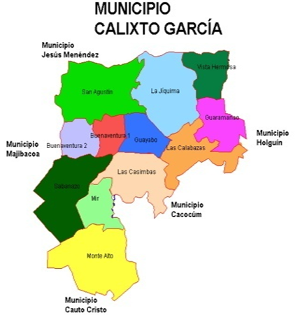
The westernmost of the municipalities of Holguín borders to the north with "Jesús Menéndez" in Las Tunas; to the south with Cauto Cristo (Granma) and Cacocum; to the east with the municipality of Holguín and to the west with its similar of Majibacoa (Las Tunas).
The four main settlements, within the 94 population seats in 12 Popular Councils, are the towns of San Agustín de Aguarás , Buenaventura, which is the municipal head, Sabanazo and Mir, the latter two located to the south and next to the central railway line that crosses the territory, as well as the Central Highway that connects it with the cities of Holguín and Las Tunas.
When it was created in 1963 it had a dimension of 909 Km2 and a population of 39 035 people. When the term was transformed in 1977 it was left with a territorial extension of 616, 9 km² (6,6 % of the total area of the province) and a population of 53 028 inhabitants. This was maintained until 2010, when the People's Council of La Yuraguana was transferred to the municipality of Holguín, when it was reduced to 585.57 km².
The 2012 census showed that the population was 55,622 inhabitants. Of these 37,650 in rural areas and a population density of 94.1 inhabitants/km2. This same record showed that 51.8% of the total population was male, that 10,350 Calixteños were in the 0-14 age group, and 35,116 were in the 15-59 age group; while 10,156 were over 60 at the time. Also that 94% of the homes were electrified.
"Calixto García" is among the ten municipalities in the country with the highest proportion of white skin colored population, with 89.2% of the total inhabitants, it is the second municipality at national level with the lowest level of schooling and the fourth with the highest aging population in the province.
The territory is 73 % flat, with fertile savannahs where non sugarcane agriculture and cattle raising are developed, which represents approximately 78 % of the commercial production of the territory. It produces 11 % of the province's food volume and is the largest milk producer at provincial level.
In its central-eastern region, penetrate the heights of Maniabón, highlighting the hills of Guayabo and La Bartola, the two largest heights of the territory.
The number of heads of cattle in the hands of private owners and state institutions is considerable, however, the number of industries to transform these primary products, are insufficient and most of the production leaves the territory without processing.
The scarce hydrographic network is subordinated to rainfall regimes. The River La Rioja crosses the municipality, but climatic changes, indiscriminate felling of trees on its banks and other damage caused by man have considerably affected its course.
The local culture is closely linked to rural life, the tenth, and to the music of the eastern organ, of which they are proudly the greatest representative at the national level. Among the cultural events that are held stand out: The "Pepe Ajo" Organ Festival and the "Bachatas Campesinas de Las Mantecas", both of which have the potential to become part of cultural tourism.
The people of Calixte call, with reason, their small homeland: "The most rural of Holguin's municipalities".".